
Our first visit to the BGS Coastal Landslide Observatory since Lockdown / / by Lee Jones and Matt Kirkham
The Corona virus pandemic has affected our work in lots of different ways. Until recently, because of lockdown, all fieldwork was suspended, meaning much of our site-based science research was put on hold. Happily, and with various measures in place to protect our staff, some field activities have restarted. One site we have been able to visit is our Coastal Landslide Observatory on the Holderness coast. Here, Lee Jones and Matt Kirkham describe their new day out-of-the-office...
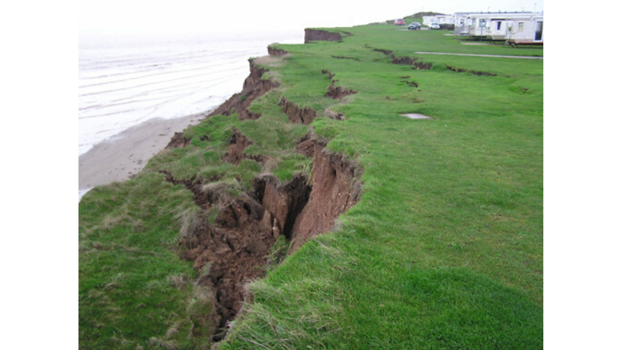 |
| The cliffs at Aldbrough are at constant risk of landslide, and monitored by the BGS team |
Location: BGS Coastal Landslide Observatory, Aldbrough,
East Riding of Yorkshire
Date: 24th June 2020
Activities: Routine quarterly site visit - LiDAR scanning,
data collection from boreholes and weather station, beach and cliff
observations
Usually we would travel
together to our Coastal Landslide Observatory in Aldbrough, East Riding of Yorkshire, but current COVID-19 health and safety regulations mean it's recommended that we both arrive at our destination separately. We turned up to a glorious sunny day, with a slight onshore breeze.
One of the main purposes of our quarterly visits is to carry out a series of LiDAR surveys of the beach and cliffs. LiDAR is short for Light Determination and Ranging and is a laser scanning device that accurately models the 3D geomorphology (physical features and relation to geological structures) of the beach, landslide, cliff and foreland of the coastal section at Aldbrough. This work allows us to measure and quantify (in terms of volume) how much the cliffs have changed since our last visit as well as identifying processes on the beach that contribute to these changes. If you want to find out more about this, there are details at the end of this blog post.
 |
| Lee taking GNSS measurements of the cliff top at our Coastal Landslide Observatory near Aldborough |
We started work around 9:30AM by beginning the LiDAR surveys, setting up the GNSS base station and connecting it to the real time network (internet). This involves setting up a Global Navigation Satellite System (GNSS) on a temporary bench mark, 30 m back from the cliff edge, and assembling the Pegasus Backpack Mobile Mapping System (one of the LiDAR). GNSS is how we determine exactly where we are on the earth’s surface, to an accuracy of <2 cm. This allows us to return to the same site time after time, and be certain that we are measuring ‘real’ change as opposed to ‘perceived’ change.
By the time I had completed the 3 km cliff-top walk and also the equivalent length at the cliff toe and the beach walk, the first of around 100 holidaymakers turned up.
In the 20 years we have been studying the erosion at the
site, and despite the advice from government about social distancing, this was
by far the most people I have ever seen here, probably as many as I have seen
in all the previous visits combined.
Apparently, the town of Mappleton further up the coast was so busy that there was nowhere to park and the late arrivals had decided to descend on Aldbrough. There is no access to the beach here; the only way down is to navigate the 17 metre-high cliffs. These cliffs are very active with landslide processes going on continuously, and an unexploded ordnance was found very recently in this area. It didn’t seem to stop the day's visitors though with one person even deciding to set up camp on top of a landslide block.
 |
| Here, the public has set up a tent on the landslide itself, while people stand below, in the landslide's direct path |
Our health and safety measures are stringent. We are trained in understanding landslides
and the risks of working in this environment. It is always shocking when we see the public putting themselves in
danger in this way. This is an ongoing
problem faced by many coastal communities and local authorities around the
country.
Matt and I continued
to carry out our work as socially distanced as possible (with mask in hand just
in case). We downloaded the data from
the piezometers in the boreholes and carried out the inclinometer survey. We also collected the data from the weather station
and completed the Terrestrial LiDAR Scanning and GNSS survey. After this, we carried out some visual
inspections of the beach and cliffs.
Compared with our last monitoring visit, in December 2019,
the slumped section of the landslide has dropped by approximately 1 metre, with
tension cracks extending north across the collapsed road. On the cliff top
itself, the ground towards the cliff has dropped 12m back from the edge. To the
north and south of the road the cliff remains active with regular slumps and
falls prevalent.
 |
| Matt, carrying out the inclinometer survey |
We completed our work and set off for home. The following day, the vehicles were unpacked, the equipment cleaned and the data downloaded back in the Keyworth office ready for analysis and comparison with previous visits. The next time we'll be on site for our quarterly monitoring will be September. It will be interesting, as always, to monitor any changes once more.
Click here for more information on the project
Comments