
Laura James is a geoscientist based in the BGS Wales office in Cardiff. Laura joined BGS in 2004 and has most recently worked on developing a 3D geological model of Cardiff. Laura also collates, captures and digitises data for a number of BGS datasets on a national scale, including Britpits, sinkholes and karst databases.
The UK must significantly reduce its greenhouse gas emissions by 2050 (at least 80% lower than 1990 baseline) to tackle climate change. To achieve these targets, sources of low carbon renewable energy are being investigated. Heat recovery and storage in aquifers is one such solution that can be applied to help address these challenges. Staff at the British Geological Survey have been investigating the potential for shallow geothermal energy in Cardiff city centre and have already created a groundwater heat map.
Shallow groundwater under Cardiff can exceed 15⁰C and these warmer than predicted temperatures are thought to be due to the ‘subsurface urban heat island effect’. The ‘Cardiff Urban Geo Observatory’ was established to characterise, monitor and model groundwater and subsurface heat flow. The observatory comprises a pilot shallow ground source heat pump, complemented by 100 temperature sensors in 60 boreholes.
To help to understand how we can manage subsurface heat in Cardiff, we developed a 3D model of the superficial deposits to characterise their thickness, volume and lateral and vertical distribution. The 3D model helps us to better understand the geothermal aquifer dimensions. A series of 340 cross-sections have been constructed, to form a fence diagram using the Geological Surveying and Investigation in 3D (GSI3D) software package.
The sections cover much of the most densely populated areas of the city centre. Geologist’s knowledge has been applied to incorporate subsurface data (1330 boreholes from a total of 3090 boreholes within the project) and surface geological mapping to provide an interpretation of the geological succession, utilising BGS 1:50 000 and 1:10 000-scale geological maps.
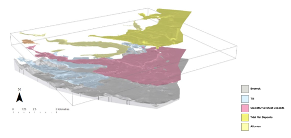
The superficial deposits in Cardiff include Till, Alluvium, Tidal Flat Deposits and Glaciofluvial Sheet Deposits. The unit with the most potential for shallow geothermal energy are the Glaciofluvial Sheet Deposits which were deposited by meltwater streams as a local glacier retreated during the Late Devensian period. These deposits in Cardiff largely comprise clayey sandy pebble-cobble gravels and because of their relatively high porosity and permeability are thought to host much of the warm water beneath the city centre.
For more information:
KENDALL, R.S., JAMES, L.R., PATTON, A.M., THORPE, S. 2018. Model metadata report for Cardiff Superficial Deposits. British Geological Survey Open Report, OR/16/031. 21pp. (Soon to be published)
Also see:
Patton, A & Boon, P. 2015.
How to Heat a City
Boon, D & Farr, G. 2019.
How to Heat a City and Decarbonise it Using Heat Pumps!
 |
| Cardiff Bay: a view of the Pierhead Building, the Senedd and Wales Millennium Centre |
Shallow groundwater under Cardiff can exceed 15⁰C and these warmer than predicted temperatures are thought to be due to the ‘subsurface urban heat island effect’. The ‘Cardiff Urban Geo Observatory’ was established to characterise, monitor and model groundwater and subsurface heat flow. The observatory comprises a pilot shallow ground source heat pump, complemented by 100 temperature sensors in 60 boreholes.
 |
| Distribution of cross-section lines (dark red) and the boreholes (yellow) used in the construction of the model |
The superficial deposits in Cardiff include Till, Alluvium, Tidal Flat Deposits and Glaciofluvial Sheet Deposits. The unit with the most potential for shallow geothermal energy are the Glaciofluvial Sheet Deposits which were deposited by meltwater streams as a local glacier retreated during the Late Devensian period. These deposits in Cardiff largely comprise clayey sandy pebble-cobble gravels and because of their relatively high porosity and permeability are thought to host much of the warm water beneath the city centre.
 |
| View of the model looking across the harbour to the north showing all modelled units (5 x vertical exaggeration) |
 |
| Exploded view of the model units, looking from the southwest corner, eastwards |
Our aim is
to use the 3D geological model to create a hydrogeological model, populated
with long term groundwater level and temperature data. The model will allow us
to plan sustainable heat recovery and storage systems across the city. Once
finalised, our 3D geological model will be open access and will support heat
recovery and storage projects in the city of Cardiff.
 |
| View of all cross-sections in 3D, looking across the harbour to the north |
KENDALL, R.S., JAMES, L.R., PATTON, A.M., THORPE, S. 2018. Model metadata report for Cardiff Superficial Deposits. British Geological Survey Open Report, OR/16/031. 21pp. (Soon to be published)
Patton, A & Boon, P. 2015.
How to Heat a City
Boon, D & Farr, G. 2019.
How to Heat a City and Decarbonise it Using Heat Pumps!
Comments